Early wheat planting recommended for drought-affected plains, El Nino’s impacts somewhat delayed from Rockies to Plains
Here are the specifics of the latest Climate Prediction Center’s autumn forecast-from the central Plains to the Rockies:
KANSAS:
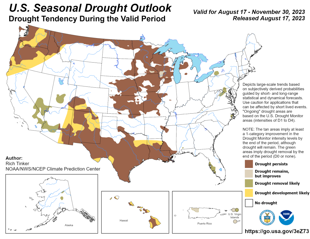
For farmers in parts of the Great Plains coming off of a nail-biting summer of dryness and in some cases extreme-to-exceptional drought, the latest autumn forecast issued Thursday, Aug. 17, 2023, from the Climate Prediction Center includes eventual hope for effects of the El Nino-driven wetness, as well as guidance about working through a quicker harvest to reap benefits of current soil moisture. First though; Kansas and the Midwest have to get through the excessive heat the week of Aug. 21. “I’m very concerned about that heat, which may result in rapid degradation during times of needed precipitation for summer crops,” said Christopher “Chip” Redmond, assistant meteorologist and Mesonet manager at Kansas State University. After three straight years of (dry) La Nina, many in the central Plains have been looking forward to the switch to the opposite climate phenomenon El Nino for more wetness, although its full impact appears delayed. The CPC is leaning slightly towards warmer than normal temperatures statewide. However, precipitation is more uncertain with equal chances for having either near normal/or above or below normal moisture. “Currently, it appears that the dominant high pressure (causing the intense heat) will break down early September with lingering tropical moisture entrained into it. This will provide some relief to the very hot/dry conditions and is hopefully not too late for crops,” Redmond said. Later in September, the El Nino-enhanced southern jet stream is expected to shift southward; providing moisture for one-to-two weeks, before sliding south of the region in October, Redmond said. This could complicate harvest, but help early wheat planters.
DROUGHT IMPACT
Drought has been a struggle in parts of the central Plains; notably covering Kansas and Nebraska with 66 and 52 percent of the landscape, respectively; as of Aug. 15, according to the U.S. Drought Monitor. “While the autumn precipitation outlook is less certain, with the central Plains caught between El Niño wetness in the southern U.S. and dryness across the north, there are, of course, other factors besides El Niño that could influence autumn weather patterns,” said Brad Rippey, USDA meteorologist, Office of the Chief Economist-World Agricultural Outlook Board, Washington, D.C. The weather will be much more sensitive to additional oscillations with impacts to Kansas as well, Redmond added. That’s encouraging news, especially since drought combined with periods of extreme heat have adversely affected rangeland, pastures and a variety of summer crops, including corn, soybeans and sorghum. In Kansas, extreme drought (D3) was observed across several counties from central and southeast Kansas. Exceptional drought (D4) was located across Elk and Chautauqua counties east of Wichita. The U.S. Department of Agriculture on Aug. 13, reported that 33 percent of the rangeland and pastures in Kansas were rated in very poor to poor condition, along with 23 percent of the corn, 21 percent of the soybeans and 18 percent of the sorghum, Rippey said.
NEBRASKA:
As meteorologist Mike Moritz put it, “Not a lot to hang your hat on,” as the CPC is also forecasting “equal chances” for Nebraska to have either near normal/or above/or below normal precipitation this fall. Average temperatures are expected to be above normal across the central Plains in September, but drop back a bit thereafter.
The development of El Nino in the central Pacific Ocean and current moisture conditions are “driving’ this seasonal outlook.
“We should be normal to wetter, especially when compared to the last three years of La Niña. So, a continuation of the spotty, high variable precipitation (we’ve seen the last three months) is likely. With only equal chances in the outlook, I can’t say it would be much different,” said Michael L. Moritz, warning coordination meteorologist, NWS, Hastings, Neb.
“Warmer than normal temperatures in the Pacific Ocean have been observed and El Nino is already occurring. Current long-range models point toward a strong El-Nino event occurring, then centered in December, January and February.
DROUGHT CONDITIONS
Large sections of Nebraska (in addition to Kansas) remain in drought. Exceptional drought (classified as D4) was noted in south central Nebraska across parts of Nance, Merrick, Hamilton and Clay counties, with extreme drought (D3) in surrounding counties.
In a unique twist this year, far western Nebraska and western Kansas were considered drought-free, as of mid-August.
Areas which have been wet in recent months, are generally expected to be in better shape thanks to dramatically improved soil moisture conditions.
“Some will reap the benefits of beneficial rain for fall planting (wheat), while others who are dry may be able to work through a quicker harvest, though soil moisture conditions will likely remain sub-standard into the winter,” Moritz observed.
COLORADO:
Areas of the central Plains closer to the Rocky Mountains have fared better, with no drought observed by mid-August in eastern Colorado and environs. Also, El Nino is in-place and expected to continue through the winter months. “This El Nino event will likely be on the stronger side (anomalies ~+1.8 or greater). Looking at the general El Nino pattern, its warm north, although cool and wet south,” said said Kyle Mozley, meteorologist, National Weather Service; Pueblo, Colo.
El Nino is expected to produce to wetter September and November months in eastern Colorado.
“Of course much will depend on how other climate signals (the Arctic Oscillation, North Atlantic Oscillation and Pacific North American oscillation, etc) evolve over the coming season, as they too, will have an impact. The PNA pattern is tricky to forecast beyond two weeks, Mozley said. But looking strictly at El Nino, a wetter September-November period is likely for Colorado, as well as western Nebraska and western Kansas.
WINTER SNOWPACK IMPACT
After an above-normal winter snowpack in the western U.S. this past winter that resulted in flooding, there’s still flooding; although there’s also the unfortunate dichotomy of drought in a few areas of Colorado.
First; the state average snowpack across Colorado was 136% of normal. Most of this snowpack was observed over the Rio Grande Basin (San Juan Range), with areas of the Arkansas River/Platte Basins running 90-110% of normal snowpack, and Sangre de Cristo Range in the 60-80% range. While much of Colorado had a good snowpack, it melted off quickly, by mid May, which led to the Rio Grande running high, although it never reached flood stage (there were a few reports of minor low land flooding in agricultural low spots near Del Norte). “However, areas along La Jara Creek, the Conejos River and San Antonio River had pretty high flows and flooding over southern portions of the San Luis Valley (May to June). We talked to a farmer along La Jara Creek a couple weeks ago, who had never seen flooding that bad (he’s been there 25-plus years). He mentioned the creek is normally about 9 feet below his bridge decks to his property, and he was afraid he was going to lose his bridges,” Mozley said.
Probably the biggest response was in water supply. Statewide, the reservoir went from around 75% of normal capacity, to over 80% through the summer. The Upper Rio Grande Reservoirs went from around 20% last year, to near 40% this year, Mozley said.
Regarding any drought, Colorado fared pretty well. Although no part of the state had drought conditions in early July, that did change quickly in western sections.
“Boy, how that changed in August. For west central to southwest Colorado (areas that had the highest snowpack) abnormally dry-to-moderate drought emerged over the past couple of weeks. I believe this is in response to the lack of monsoonal moisture,” Mozley said. The monsoonal moisture, which normally starts in early July, really didn’t get going until late July, and has not sustained itself through the first half of August. With the main monsoon moisture plume well off to the west, it’s not likely to help out through August, so drought conditions may continue over southwest Colorado.
On the positive side, Mozley said, eastern Colorado had a pretty wet spring and summer, and no drought conditions exist there.
WYOMING:
Wyoming got a big break from drought this year so far, and the CPC autumn outlook for Wyoming predicts equal chances of having: normal, above-normal, or below-normal precipitation. “In cases like this, the safest bet is to look at climatology for what to expect,” said Tony Bergantino, director-Wyoming State Climate Office and Wyoming CoCoRaHS State Coordinator-Wyoming Mesonet director. It all depends upon the specific location in the state.
For example, in Cheyenne, normally August and September precipitation are about the same with a drop-off into October. Wheatland has August to October precipitation roughly comparable to each other. For Laramie, typically August and September are similar with a much less drastic drop off going into October. In Casper, September usually sees a bit more precipitation than August, with October higher and more comparable to June.
Since Wyoming is a big state with a lot of different climates, Bergantino can offer Wyoming residents his specific forecasts for other locales, if desired. Meanwhile, El Nino is expected to persist into the winter and some computer models are predicting a strong one through the December-January-February period. “If you look at historical precipitation rankings for the October to December time period during El Nino events, Wyoming is typically near normal with a few climate divisions (Powder-Tongue, Belle Fourche, Snake) being slightly on the dry side, and the El Nino signal not really kicking in until the November to January period. Temperatures lean above-normal especially in western Wyoming. The farther northeast one goes, Wyoming has the equal chances’ (average) category.
DROUGHT RELIEF
In Wyoming, the large amount of snowpack in the lower elevation from central and south central to southwest Wyoming unfortunately was a problem for livestock interests during the early part of the year, especially when coupled with the cold temperatures. “When the snow began melting, there were flooding concerns, and some areas experienced high water. However, dry soils from the previous drought meant much of it went into the soil column, which helped improve those conditions and mitigate some of the flooding effect,” Bergantino said.
There were several flooding occurrences later from intense June and July thunderstorms, notably in Cheyenne, Casper and Laramie. Thanks to all the precipitation, the drought monitor stands at its lowest level of coverage since mid-July 2019. The exception is D0 up in northwest Teton County, reporting abnormally dry. That area is either coming out of drought or drought could be imminent, Bergantino explained. “And, the last time prior to the 2019 situation where the D0-D4 levels in Wyoming were this low was back in early November of 2011,” Bergantino said, adding, “The last of the D1 or Moderate Drought was removed from the map (week of Aug. 14), making it the first time since May of 2020 that there has been no drought in Wyoming.”