Record-strong winds walloped Intermountain West
Wind3-RFP-122925
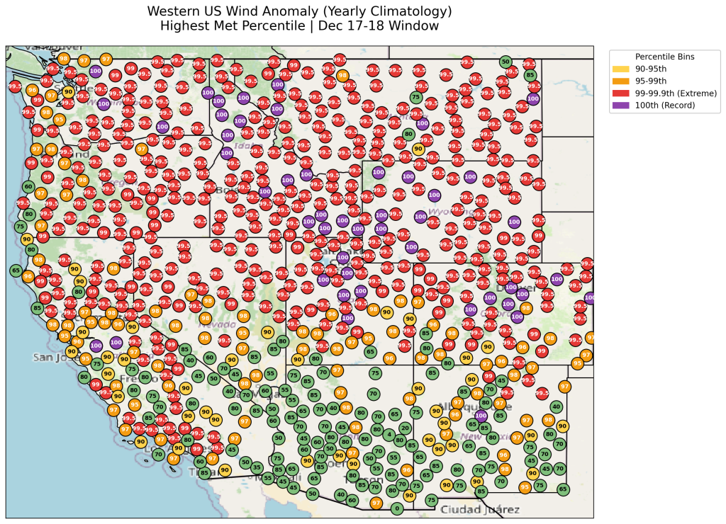
A powerful widespread zone of fierce winds that whipped through the northern Rocky Mountain states and the Northern Plains the week of Dec. 14-19, is being classified as a record-strong wind event. The massive wind scale delivered new record-strong wind gusts throughout the Intermountain West, from Colorado, Wyoming, Montana, Utah, Idaho, Washington state, central California and central New Mexico, also in the Dakotas in mid-December.
“Here in southeast Wyoming, the area is no stranger to high winds. The windy season is typically November to April and we get some gusts over 80 mph during the season. But, it was the magnitude of the winds all week,” said Shelby Fuller, meteorologist, National Weather Service in Cheyenne, Wyo.
Almost every other day in mid-December winds were relentless. The 90 mph wind gusts entered the forecast area Monday, Dec. 8, keeping it windy all that week followed by that big wind event on Dec. 14-19.
STAGGERING GUSTS
The National Weather Service in Cheyenne reported 75 mph wind gusts Friday, Dec. 19, and 69 mph gusts Dec. 17.
Casper, Wyo. had a 78 mph wind gust on Dec. 17 and gusts to 76 mph on Dec. 19.
Lander, Wyo., had a gust of 92 mph on Dec. 17.
At the Billings, Mont., airport, gusts to 79 mph occurred Dec. 17. In Livingston, Mont., gusts throttled into the 82 mph range.
Rapid City, S.D., reported a record 94 mph gust Dec. 18.
Bismarck, N.D., had a 67 mph gust Dec. 18.
The strongest winds in Colorado were in the foothills and mountains, with some gusts reported over 120 mph.
“More unusual though, was the swath of 70-80-plus mph gusts across northeast Colorado, which doesn’t get winds that strong, nearly as often,” said Russ Schumacher, Ph.D., Colorado State University climatologist and director of the Colorado Climate Center.
Specifically in northeast Colorado, there were two wind events on Dec. 17 and 19. The strongest winds were across the high country (mountains to the west), and down into the front range (along and west of I-25,) with 50 to 70 mph winds spreading across the lower elevations.
“Down here in southern Colorado Dec. 17, we had widespread 60-80 mph winds across the higher elevations, with 50-70 mph winds west of I-25,” said Kyle Mozley, meteorologist with the National Weather Service in Pueblo, Colo. Ninety mph winds were reported across the higher elevations in Fremont County on Dec. 17.
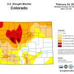
“La Nina can be somewhat to blame, with typical warm and windy conditions across Colorado, and little snowpack so far this winter. Hopefully, snow will pick up over the next couple of weeks,” Mozley said.
In Utah, a 120 mph gust pummeled the exposed Hidden Peak east of the Salt Lake Valley near the Alta Ski area on Dec. 17. Known damage reported a tree falling on a house in Huntsville, and a tree falling on a coffee roasting facility in Logan.
HOW IT HAPPENED
“A combination of strong high pressure to the south and strong low pressure to the north contributed to the strong winds. We also had a strong jet stream moving across the northern Rockies coupled with a favorable atmospheric stability profile that enhanced terrain-driven winds,” said Alex DeSmet, warning coordination meteorologist with the National Weather Service in Salt Lake City, Utah.
That “favorable atmospheric stability profile” is being called, “a perfect storm” including several meteorological factors that just all came together.
Those included extra strong upper-level jetstreaks (regions of fast-moving air embedded within the jetstream) moving below the mountains, in areas of complex terrain. When the mountain waves break it sends really strong winds down to the surface, which produced 90 to 100 mph wind gusts, Fuller said.
Robust winds on the east side of the Rockies are not surprising, however, strong westerly winds aloft coming off the Pacific Ocean moved off the Rockies which caused (induced) that very strong area of low pressure on the east side of the Rockies,” said Joe Lester, lead meteorologist with the National Weather Service in Billings, Mont. “Additionally, inversions up near the top of the Rocky Mountains squeezed out air over the mountain and the flow perpendicular to the mountain ranges all came together for the record-strong winds,” Lester added.
Taking a deeper dive into meteorology, Lester attributed it to the “Bernoulli Effect” (named after mathematician Daniel Bernoulli, in the book Hydrodynamics about air, water and their movements), that when you increase speed, it causes a decrease in pressure.
“Regarding the Bernoulli effect, air is just a fluid, and it’s like holding a garden hose. If you put your thumb over two-thirds of the hose, the water comes out narrower and faster. So, if you squeeze air (like on the top of the mountain) it’ll accelerate down the mountain,” Lester explained.
“The strong temperature contrast between the warm south/southwest and cold north/northeast winds — typical of a La Nina — played a role,” said Christopher ‘Chip’ Redmond, meteorologist and manager of the Kansas State University/State Weather Data Library/Mesonet. These types of systems become quite frequent in the late winter when wildfire potential and severe weather increase in Kansas.
“The more tightly packed (or shorter the distance) that temperatures are the faster the wind. There is a tendency for winds to howl across the Front Range simply due to the mountains and canyons. The canyons can really concentrate winds like a funnel, so the air is forced to move faster to get through, but these were historic, wind speeds,” said Doug Kluck, retired, National Oceanic and Atmospheric Administration Central Region climate services director.
That strong low pressure system moved from North Dakota east/southeast into Minnesota causing a large difference in pressure from northwest to southeast over the region, leading to the strong winds.
“But, as it moved south eastward the tight pressure gradient weakened, and the winds became lighter,” added Ruben Behnke, Nebraska Mesonet manager and applied meteorologist.
“In Kansas, there’s cause for concern going forward; especially considering all the vegetation growth we saw last year. If we don’t get snow or widespread moisture in the meantime, we may see more devastating fire events,” Redmond noted.
warning coordination meteorologist, National Weather Service, Salt Lake City, Utah