Slow going, so far, for Intermountain West snowpack
Farmers and ranchers in the Intermountain West are closely monitoring the February and March forecasts with hopes that these next two months could possibly produce what would typically be their heaviest snowfall. So far, this winter has left parts of the Intermountain West high and dry, even at higher elevations. But, winter isn’t over yet, and some say the snow has been coming, just at a slower pace.
All five states in the Intermountain West region (Arizona, Colorado, New Mexico, Utah, Wyoming) had their warmest December on record.
The recent record-setting warm weather in the West produced rain, instead of snow, particularly at mid-elevations. Unfortunately, these conditions combined to cause the “perfect non-storm” needed for the region’s critical water supply. Some stations are recording their lowest or near lowest snowpack, thus far.
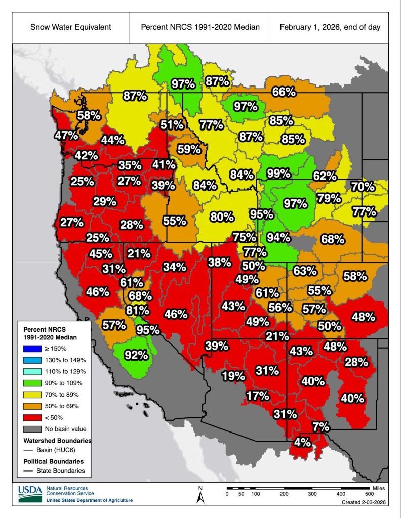
Officials with the National Oceanic Atmospheric Administration’s National Integrated Drought Information System reported, as of Feb. 1, that snow cover across the Western U.S. — including the Intermountain West region and the rest of the western states of Montana, Idaho, Washington, Oregon, California and Nevada) covered 139,322 square miles — the lowest Feb. 1 snow cover since 2001. Colorado, Utah and Oregon are reporting the lowest statewide snowpack.
Snowpack, which is critical for economic and ecological importance to western communities, is present at higher elevations but has melted or is not present at many lower elevations.
However, there is still time to reach average peak median snow water equivalent (SWE), which occurs in March and April in most basins in the West. Officials say snowfall deficits will be difficult to make up, but appreciable snowfall over the next couple months would help a great deal.
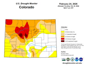
COLORADO
Colorado has received only half it’s normal snowfall, at this point.
“I’d say much of Colorado’s snow pack ranges from 50-70% of normal and mainly at higher elevations,” said Doug Kluck, retired, NOAA Central Region Climate Services director.
Snowpack has not actually “declined” over the Colorado Rocky Mountains this winter, another climatologist noted. “It is continuing to build at least at the elevations where we measure snowpack. However, it is building much more slowly than a normal year. Colorado statewide snowpack is the lowest it has been at the end of January in modern SNOTEL records, which only go back to 1987,” said Peter Goble, assistant state climatologist, Colorado Climate Center-Colorado State University. SNOTEL stands for SNOwpack TELemetry Network or Snow Telemetry, which is an automated system of snowpack and climate sensors operated by the Natural Resources Conservation Service. “The lower snowpack that’s currently at the higher elevations is attributed to just not having many snowpack-building precipitation events this year. It has been dry, and that’s why snowpack levels are so low,” said Paul Miller, service coordination hydrologist at NOAA’s Colorado Basin River Forecast Center in Salt Lake City, Utah.
The complicating factor is that it has been so warm for so long. “What that does is melt any low to medium elevation snow that had previously fallen. That’s not good for the reservoirs because for water supply you want a snow reservoir that melts out slowly so you can stretch out the water much longer,” Kluck said. Also, with the very warm temperatures, some of the precipitation fell as rain which helps to an extent, Kluck said, but snow is needed. Ski resorts are hurting big time too, he added.
Lake Powell and Lake Mead currently are not at record lows. They were lower before getting a desperately needed boost from the 2023 snow season. “However, with much below-normal stream-flows forecast across the basin this spring, we may end up back in record low territory later this year,” Goble cautioned.
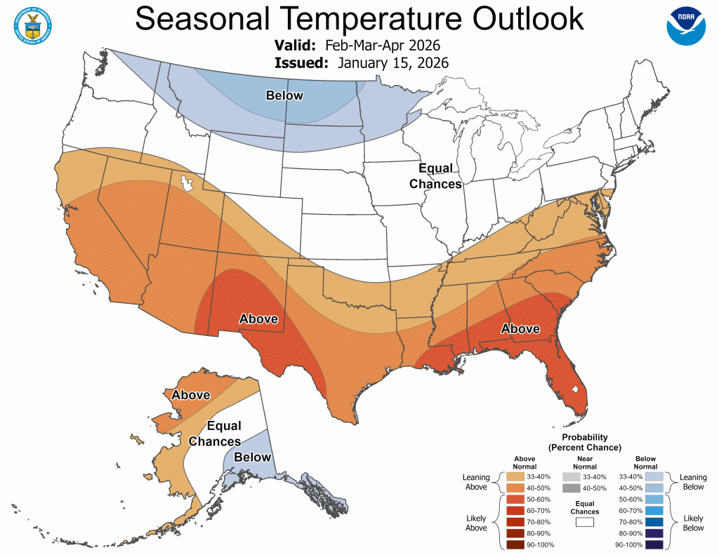
This year is behaving, so far, like a La Niña year with the southern U.S. being drier and warmer than normal, Kluck said.
So, let’s talk about the weather pattern. There have been many days of high pressure conditions over the south-central or southwestern United States this winter with abnormally warm, dry air flowing into the Intermountain West.
“High pressure has blocked us from receiving Pacific moisture and mostly shielded us from cold air outbreaks. This weather pattern has been a transient feature, but we have seen much more high pressure and warm, southwesterly flow conditions, than a normal winter. We know our average temperatures are getting warmer due to climate change, and we know southern Colorado is often drier than normal during La Niña,” Goble said.
Taking a deeper dive into meteorology, there are three main climate phenomena attributed to the low snowfall over the mountains so far this winter. “These are a positive PNA (Pacific-North American) teleconnection pattern, negative AO (Arctic Oscillation) and La Niña. The PNA tends to feature an upper ridge across the West Coast, and negative AO has a trough over the eastern states. La Niña tends to enhance this pattern,” said Kyle Mozley, meteorologist, National Weather Service, Pueblo, Colo. This pattern favors northwesterly flow across Colorado, which is typically drier, warmer and windier.
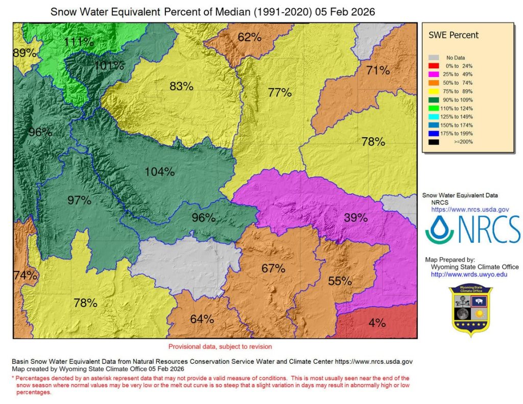
WYOMING
For the past 60 days, temperatures in much of Wyoming have been 7-10 degrees above-normal, except for the higher-elevations and even those were still above-normal.
Snowpack conditions in Wyoming are continuing to deteriorate. While the western, more mountainous side of Wyoming is doing better than the east, it is still only around the median.
“Today, (Feb. 5) only the Yellowstone Basin in Wyoming, the Wind, and the Shoshone Basins are above the median, (meaning at or above 100% of median)” said Tony Bergantino, director of the Wyoming State Climate Office and Wyoming Mesonet director.
Currently, northeast Wyoming Basins range from 62% of median in the Tongue River Basin to 78% of median in the Cheyenne/Niobrara Basins. The Cheyenne/Niobrara and Belle Fourche Basins (at 71% and 78% of median, respectively) are low-elevation basins with the stations from which those percentages are derived in the Black Hills. The other basin in northeast Wyoming — the Powder River — currently stands at 77% of median.
“Five of the SNOTEL stations are seeing record low amounts for this date, and low-elevation snowpack is almost non-existent.” Bergantino added.
ARIZONA
As of Feb. 4, Arizona’s snow water equivalent is just 31% of median.
The Little Colorado basin is 28% of median. The Verde basin is 20% of median. Gila basin is 32% of median and the Salt is 16% of median.
“Some individual SWE instruments in more common Arizona locations include near Flagstaff (instrument name is Snowslide Canyon) and is at 82% of median SWE. The Mogollon Rim’s Happy Jack is at 30% of median SWE, and the White Mountains instrument name is Baldy and is at 18% of median SWE as of 2/3/26,” said Erinanne Saffell, Ph.D., Arizona State climatologist and director of the Arizona State Climate Office.
February and March historically see the most snow of the winter months. However, that may not be enough to make up for deficits across the region.
But, there’s hope, as there is still a lot of the season to go where the mountain snows can make a comeback. “February still provides opportunities for winter precipitation, and often March is quite stormy and can lead to very high snowfalls,” Kluck said.
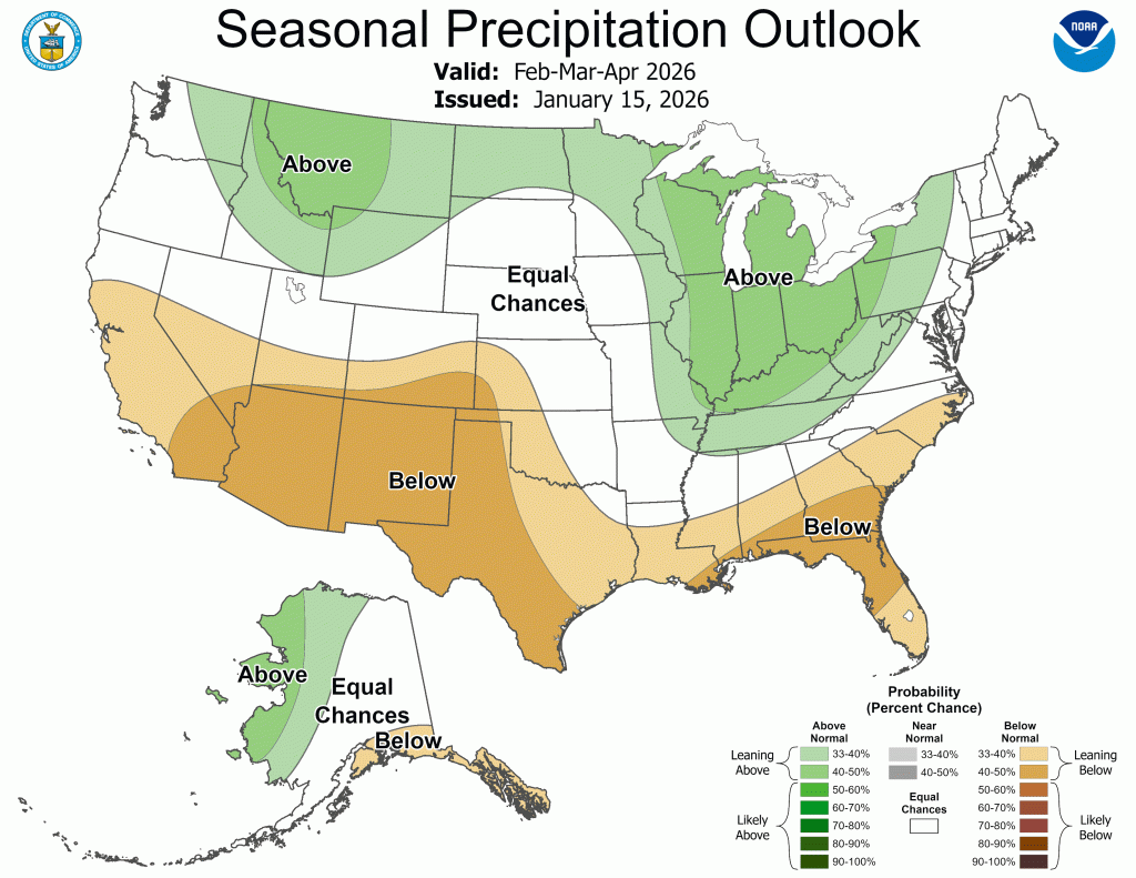
In fact, wetter-than-normal conditions are forecast across the west, in conjunction with a pattern shift into mid-February. However, parts of the west are also indicated to have warmer-than-normal temperatures.
The Intermountain West status is scheduled to be updated during a National Integrated Drought Information System webinar on Feb. 19.
Lastly, the Intermountain West winter snowpack is about one-half or a bit less of the “accumulation season,” meaning that by April sometime it normally reaches peak, so there’s still hope for more snowpack.