El Nino, summer moisture desperately welcomed in Rockies, Central Plains
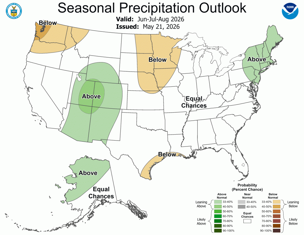
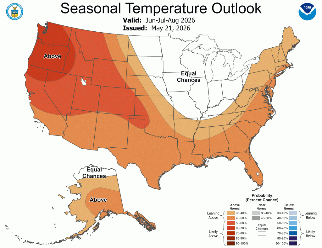
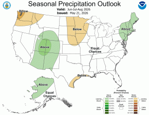
Optimism is the forecast highlight for moisture for the Central Plains and Central Rockies, from late May into June, with chances continuing into the summer, according to the outlook for June, July and August issued by the Climate Prediction Center on Thursday, May 21. It can’t come soon enough for the Intermountain West, and also drought-plagued western Nebraska and parts of Kansas.
Above-average chances of precipitation are indicated for Nebraska and Kansas. By June, southwest Kansas still has decent precipitation chances.
As summer progresses, Kansas, as well as western Nebraska, have equal chances of average moisture. However, there are below-normal chances for precipitation for eastern Nebraska and western Iowa as summer progresses.
Previously, this summer period was projected to be favored toward below-normal for Kansas into Nebraska, weighted heavily on the faded La Nina rapidly growing drought and the developing El Nino building high pressure.
“However, recent rainfall, especially to the south of Kansas has improved drought in that region. This will be more effective at transporting moisture northward. Additionally, the onset of El Nino conditions rapidly developed with a strengthening of the sub-tropical jetstream,” said Christopher “Chip” Redmond, Kansas State University meteorologist and Kansas Mesonet manager.
Summer crops in the ground in Kansas will likely benefit from wetter conditions. However, the lack of sub-surface soil moisture from rapid drought will need to be replenished, ensuring these crops can withstand any duration of hot and dry conditions which may present themselves.
“Grazing, especially in the west/central areas will likely not recover fully, even with above normal moisture. Both warm and cool season growth is below normal already with projections expected to remain that way,” Redmond said.
Despite some late season wildfires, the expectation is that the wildfire season in Kansas will come to an end with more widespread greening, Redmond told The Fence Post. Irrigation concerns are higher than normal, as many producers had to start irrigation earlier in the season due to the rapid onset of drought. This may have later impacts on water budgeting in areas where water use is regulated.
“The CPC’s forecast of much of the region being in ‘equal chances’ for precipitation is partly a reflection of the uncertainty of El Nino impacts later in the summer. Other teleconnections will matter as much, if not more than El Nino this summer. The warm water off the Baja and the Pacific Northwest that is expected to be in place over the summer, has not historically favored major drought development in the Central Plains and western Corn Belt,” said Eric Hunt, Ph.D., assistant Extension educator of Agricultural Meteorology and Climate Resilience, University of Nebraska-Lincoln.
EL NINO
El Nino is likely to emerge soon, with an 82% chance from May to July 2026, and continue through winter 2026-2027 (with a 96% chance of being in place from December 2026 to February 2027). El Nino (the opposite of La Nina) is expected to bring some relief to the southwest U.S. through above-normal precipitation and cooler temperatures. Farmers and ranchers are anxiously watching the forecast, as much of the Intermountain West region is dealing with drought, due to a spring heat wave and record-low winter snowpack.
Thankfully, there are respectable chances for precipitation the last week of May — from May 27-31 — for Kansas and Nebraska, as well as into Colorado and parts of Wyoming, especially southeast Wyoming.
As June progresses, the CPC forecasts above-normal moisture chances from Colorado into the western third of Kansas.
Then by mid-summer, when the Monsoon season typically takes center stage, above-normal chances for precipitation are forecast for the Intermountain West states of Arizona, New Mexico, Utah and Colorado and pushing northward into most of Wyoming. Extreme northern Wyoming has equal chances of either average, above or below-average. Monsoon means a seasonal reversal of the wind pattern, with moisture moving up into the four corners region where Colorado, Utah, Arizona and New Mexico connect. It’s hoped that this summer’s Monsoon season could bring much-needed rainfall to this region.
SNOWPACK UPDATE
Although April and May snowfall in some areas didn’t counteract the seasonal snow deficits, these latest snow events were able to increase soil moisture and hold onto some of the high-elevation snowmelt. Officials at the National Oceanic Atmospheric Administration’s National Integrated Drought Information System say this may slow drought deterioration can temporarily mitigate early season wildfire risk.
However, this year’s peak snowpack is considered the new “benchmark low” for Wyoming, Utah, Colorado and New Mexico. In these states, snow water equivalent or SWE around April 1, the usual peak date, was 32-53% lower than the previous record low.
Meanwhile, some of the drought impacts from across the Intermountain West include reports of rivers starting to run dry, hauling of water and feed for livestock herds, increased wildfire risk, and requests for voluntary and mandatory water restrictions.
In the Colorado River Basin, long-term drought, combined with high temperatures and the lowest winter snowpack on record, have reduced the Colorado River system storage.
An Intermountain West webinar Tuesday, June 16, will provide the latest information about regional drought conditions. It will also include an update on the status of the 2026 North American Monsoon outlook and the developing El Nino, and how it may impact drought in the region. The state of Colorado will also share their approach to drought preparedness.
DROUGHT CONDITIONS
Currently, the western two-thirds of Nebraska is in an extreme drought. Far eastern Nebraska ranges from severe drought. lessening down to just abnormally dry, and even no drought at all in southeast Nebraska, where they recently received abundant rainfall.
Other parts of Nebraska that desperately needed rain, finally caught a break in the second half of May.
“In the short-term, we had a pretty significant system move through Thursday into Friday, May 21-22, with 1-3 inches of rain over the central and northeast part of Nebraska, and the forecast leans toward being more active. May and June contribute to about one-third of our year-long precipitation,” said Shawn Rossi, lead meteorologist at the National Weather Service in Hastings, Neb. Currently, drought persists, but the forecast favors above-normal precipitation through this summer, so there’s some hope there will be improvement in the drought conditions as we go through the next couple of months, Rossi added.
Drought across western Nebraska, also encompasses a large part of Wyoming; especially east/central Wyoming, which has been in the extreme drought category. The rest of Wyoming is in severe drought. The northwestern part of the state has fared the best so far, and is just considered abnormally dry, which is the low end of the drought categories.
Each corner edge of Colorado has a section of extreme drought. But, in western Colorado there’s a large chunk of extreme drought, and an even higher drought category of the burgundy-red/brown color of exceptional drought in west central Colorado.
Thankfully in Kansas, the eastern half of the state is in the clear, currently. However, southwest Kansas has the bullseye of the dark red section of extreme drought. There’s also a pocket of extreme drought in south/central Kansas. Otherwise, the western half of Kansas ranges from just abnormally dry up to the next level of severe drought.