Early April could bring precipitation to parts of Rockies, Plains

With all eyes closely watching weather forecasts for any much-needed moisture, early April may bring some hope for precipitation in parts of the Rocky Mountain states and the Plains. Several climatologists and meteorologists in Colorado, Wyoming and Nebraska agree, that while there are no big promises for long-term water solutions, weather computer models show signs of change for weather systems moving in right around the first week of April.
“Early April looks to provide a bit of a break to the hot and dry conditions that we have been experiencing,” said Tony Bergantino, director, Wyoming State Climate Office, Wyoming CoCoRaHS state coordinator – Wyoming Mesonet director. However, it wouldn’t be close to solving our water supply problems, Bergantino noted. CoCoRaHS is the Community Collaborative Rain, Hail and Snow Network, with volunteers helping measure precipitation nationwide.
COLORADO
Colorado climatologists and meteorologists agree there are signs for hope. “Overall, I would say the forecast for the first part of April is trending in the right direction, but it would take a big storm to make a dent in our current drought conditions,” said Peter Goble, assistant state climatologist, Colorado Climate Center and also the Colorado CoCoRaHS coordinator.
Right now, there is some computer model agreement around seeing a couple of troughs early in the month, but the strength, placement and moisture content of these low pressure systems are still “all over the map,” Goble noted. There could be a big event in the first week or two of April, or there might just be wind.
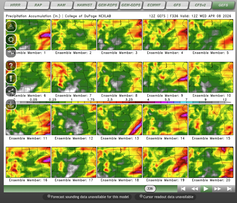
The weather computer model called Global Ensemble Forecast System or GEFS ensemble indicates some moisture in the mountains, although certainly not enough to save Colorado’s snowpack. A few of the models show significant moisture for the Front Range and/or Plains states, but not enough to feel fully confident.
“Trends are definitely there. While any precipitation is beneficial, the mountains are so far behind, we’d need feet of snow to make up the deficit,” said Kyle Mozley, meteorologist, National Weather Service, Pueblo, Colo.
And, the tough part is that with temperatures being warm, much of what looks to fall may be rain, he said.
“Rain on top of snow isn’t overly great. It can cause the snowpack (what little there is), to melt more rapidly, leading to larger amounts of runoff (and some potential for flooding, but it is too early to tell about that,)” Mozley observed, noting there are still variables and time. The Madden-Julian Oscillation (MJO) looks to be the main forecast driver, as it moves into Phase 1, which leans wet for western Colorado. While it would still take much more to make a dent in the deficit, there are some hopeful signs for, at least a bit more active weather period in early to mid April.
WYOMING
“I do see the next little while to be favorable for increased precipitation (of course right now increased precipitation could be defined as “hmm, it looks like it might rain.”) Bergantino said.
There are a few basins in Wyoming where, from this point forward if they received record maximum increases to the snowpack, they’d get close to median peak snow water equivalent (SWE) for places including: Snake, Yellowstone, Shoshone, Wind and Sweetwater, however, the chances are not favorable for that, though.
“So far, only the Yellowstone Basin has reached its median peak SWE (barely) and that was on the 18th of March (37 days earlier than its median peak date). Most basins are on the downward path at the moment though, obviously that can still turn around. A lot of ground to make up in places, however,” Bergantino said.
For example, Wyoming’s Powder River Basin would have to add almost 4 inches of snow water equivalent to get to the median. A basin that has tracked fairly well this year, the Wind, would need about 3 inches of SWE to get back to the median. The Upper North Platte, which has been skidding along the minimum for most of the season before dropping below it in the last two weeks would need about 8 inches of SWE to get back up to the median.
“Of the basins I listed above, most of them are in the northwest, which is likely to see above-normal precipitation close to early April. I would expect that we will see some temporary relief with some snow in especially the higher parts of Wyoming, but I wouldn’t rule out the chances of some rain on the lower snowpack, initially,” Bergantino said.
ROCKIES AND PLAINS
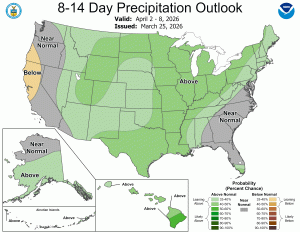
The MJO is active through phases 7-8-1, and the longer range ensembles and weekly forecasts suggest precipitation chances increase around March 31, a Nebraska meteorologist agreed.
“Those precipitation chances linger into Easter, and possibly last two to three weeks with at least “on/off” precipitation chances. However, it is hard to say how much drought relief any precipitation will provide. The temperature structure looks “cooler” than it has been, but it is still above normal for April, especially on the Central Plains,” said Michael Moritz, warning coordination meteorologist; National Weather Service in Hastings, Neb.
Regarding snowpack in the Rockies, Moritz isn’t expecting a substantial rebound this late in the season. Looking at historical plots, almost all the basins are running at or below historical minimums for snow pack.
“The normal peak snowpack occurs during the second or third week of April (in general). However, in years with very low snowpack, the peak occurs about one month earlier than normal. Specifically for the South Platte, the normal peak is April 25. This year, the peak was March 18,” Moritz said, noting that trend is seen in almost all basins this winter. The South Platte River flows through Colorado and Nebraska, and is considered a main source of water in eastern Colorado.
A special briefing of the Intermountain West Drought Early Warning System is scheduled for Tuesday, April 7, to highlight the ongoing snow drought in the region and provide early warning on potential impacts to spring runoff and regional water supply.