Recent snow helped somewhat, but snow drought lingers
Drought2-RFP-030226
The big question is did the mid-February winter storm make a dent in the Intermountain West snow drought?
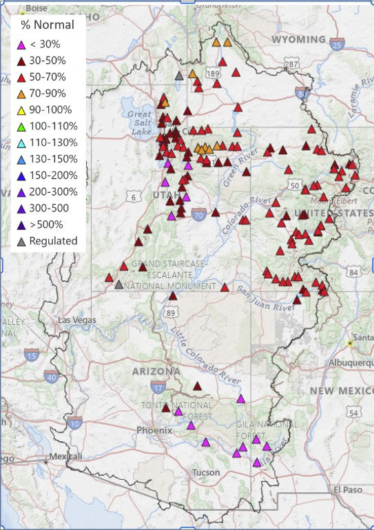
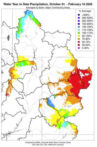
In an unseasonable snow drought year, parts of some western states were blanketed with heavy snow Feb. 19-21, just before the latest Intermountain West Snow Drought and Water Supply webinar, Thursday, Feb. 19, 2026. The short answer is yes, this mid-February winter storm will help with the snowpack, but most of the Intermountain West region (comprised of the Four Corners states of Colorado, Utah, New Mexico and Arizona) and also Wyoming are still in a snow drought, even after that storm.
Bottom line, extreme warmth and record-breaking temps have been a major driver for the severe snow drought conditions across a chunk of the Intermountain West. Above average temperatures persisted and long dry spells increased the severity of the low snowpack conditions.
“If we had average temperatures, the snow drought wouldn’t be as severe,” said Dan McEvoy, researcher with the Desert Research Institute, and one of the three speakers on the webinar hosted by the National Oceanic Atmospheric Administration’s National Integrated Drought Information System. “In some cases, the snow drought has resulted in less then 50% of the median snow water equivalent (SWE) but in other cases; less than 70% of the ‘SWE’,” McEvoy said.
SNOW DROUGHT
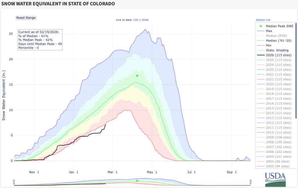
A severe lack of snowpack combined with warmer than normal temperatures results in potential impacts to spring runoff, regional water supply, and wildfire risk, the webinar speakers highlighted. Even with recent snowfall, the severe snow drought; one of the worst in the last 40 years, persists for much of the Colorado and Rio Grande Basins. Most record low areas are in Colorado and Utah.
“Regarding the Upper Colorado Basin since Oct. 1, the start of the ‘water year,’ this basin is likely to be far below normal. The Upper Colorado Basin is currently at zero percentile (record low) SWE. Recent storms have helped, but not enough to overcome seasonal deficits, especially after a long dry spell in January,” McEvoy noted. And, the Rio Grande snowpack is currently in the 6th percentile. “It started off really slowly, but then had longer dry spells than the Colorado basin, McEvoy added.
The concern is the impact on the regional water supply. It’s been a very dry year, and water supply forecasts are well below average (in the 50-60% range) throughout the Colorado River Basin and Great Basin regions.
“We just haven’t accumulated the snowpack. Recent storm activity has had only minimal impact to forecasts, but the good news is, it’s pushed up water supply, so that’s in the right direction, although not enough,” said Paul Miller, service coordination hydrologist at NOAA’s NWS Colorado Basin River Forecast Center.
The mid-February snowfall only resulted in a percentage point or two, Miller said. The Upper Colorado Basin has minimally benefited. The Lower Colorado River Basin has been more beneficial.
It’s actually considered “historically dry” in the Colorado River Basin.
“Our snowpack from most basins are near or at historically low levels, coupled with record warm temperatures. October to December were some of the warmest on record for the Intermountain West,” Miller said.
Many of the area’s SNOTEL sites (The SNOwpackTELemetryNetwork is an automated system of snowpack and climate sensors operated by the Natural Resources Conservation) are in the bottom 10% percentage. That’s because in December, unseasonably warm temperatures caused snow to melt at lower elevations.
It’s important to get the message out about just how dire this season can be, if we continue to be this dry, McEvoy said.
Officials are expecting runoff from the Lake Powell water supply. The year 2002 was the lake’s lowest on record, with 20% runoff.
“If we continue to have a historically dry spring, we could reach the record low levels, but 38% of average is what we’re forecasting. However, I don’t want to downplay it either,” Miller said. He noted there’s a very low chance that Lake Powell would get to average conditions. “We’re only hoping for 77% of average,” Miller said.
SNOWPACK
Wyoming and Utah are two of the places with an elevation gradient in snowpack. The higher elevations have a 90th percentile of snowpack, but down in lower valleys, SNOTEL locations don’t exist. However, satellite-based snow-covered areas show more.
“We divide each forecast point into elevation zones — high, middle and lower elevation zones. Low elevation typically isn’t the big contributor to the seasonal runoff… it’s the snow that melts first and can melt before the April-July period, but we include it and account for it,” Miller said.
Looking into the future, a continued rise in temperatures can cause more years, like this, McEvoy said.
After watching the webinar, Allie Mazurek, PhD., climatologist with the Colorado Climate Center at Colorado State University said they’ve been following many of the same data shared in the presentations.
“Here are some key points from the webinar that I thought were important,” she shared:
- Current Colorado snowpack remains at its worst in at least 40 years (according to the SNOTEL network).
- The current snow drought we’re having is not just driven by a lack of precipitation but also the very warm temperatures over the past few months.
- Snowpack in the Upper Colorado and Rio Grande river basins is likely to peak well-below average.
- Streamflow forecasts predict well below-average conditions for the Colorado River and Great Basin regions.
“We still have about a month and a half to go before the peak date of statewide snowpack in early April. While that still gives us a window for snow to accumulate, we need significant precipitation between now and then to help reduce our current deficits,” Mazurek said. She noted that NOAA’s climate outlook for March and seasonal outlook (both released Feb. 19) suggest Colorado has increased odds for below-normal precipitation over both of these forecast periods.
Also discussed on the webinar were fire concerns, and that hot/dry/windy conditions could carry fires. There hasn’t been much fire activity in the Intermountain West, but grasslands and a lack of snow are factors to consider, said Tim Brown, professor at Desert Research Institute & Director of the Western Regional Climate Center, who also works with fire management agencies.
“Snow is a factor determining how much grass compaction occurs. Late winter precipitation through spring precipitation will be a factor determining additional fuels growth. So, the timing and extent of the green-up makes a difference when larger fire occurrence begins. Rain will keep the fuels moistened,” Brown said. “Unless there’s some kind of switch in circulation pattern, we’ll have to wait and see.”