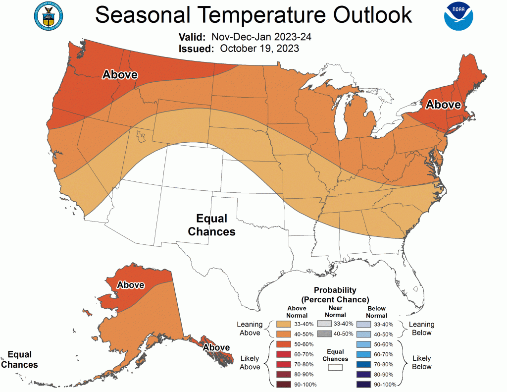
Winter 2023-2024 forecast calls for El Niño

It’s the big exchange with a classic El Niño-driven regime forecast to dominate U.S. weather this winter, after its opposite climate phenomenon La Nina held on tightly for the past three years. Farmers and ranchers are eyeing the November/December/January forecast issued by the National Oceanic and Atmospheric Administration’s Climate Prediction Center Thursday, Oct. 19, featuring a strengthening El Nino. It’s predicted to bring wetter than normal conditions across the southern one-third of the U.S., including a wetter forecast for southern and eastern Colorado into much of Kansas, but increased chances of warmer than normal temperatures across the northern U.S. While ranchers in the western U.S. remember last winter’s unusually heavy winter snowpack, farmers in the core of the Central Plains have struggled with a unique lack of moisture and drought the past year. So, the prediction of increased chances of moisture, is a welcome forecast.
“This is a reflection of an enhanced sub-tropical jet stream, which could deliver cloudy, damp winter wheat to the southern Plains and environs, thereby suppressing temperatures to near-normal levels. For places like Colorado, Wyoming, Kansas and Nebraska, this means changeable weather, alternating between periods of mild, dry weather and cloudy conditions with rain or snow,” said Brad Rippey, USDA meteorologist, Office of the Chief Economist, World Agricultural Outlook Board in Washington, D.C.
NEBRASKA
Above normal precipitation is predicted across southern Nebraska and into Kansas (33-40%), while there are just equal chances for above, below or near normal precipitation across northern Nebraska.
“With the most likely area for above normal precipitation is the southeast U.S (60% chance or more) and drier than normal conditions favored across the Great Lakes and northern Rockies (40-50% chance) in the middle in the Central Plains (Nebraska and Kansas) El Nino tends to favor wetter although not the ‘wet’ category, but there are exceptions to that,” said Michael L. Moritz, warning coordination meteorologist; National Weather Service, Hastings, Neb.
“In general, El Nino tends to favor a wetter regime, and this season it will favor the Sunflower State and southern Nebraska for wetter conditions.”
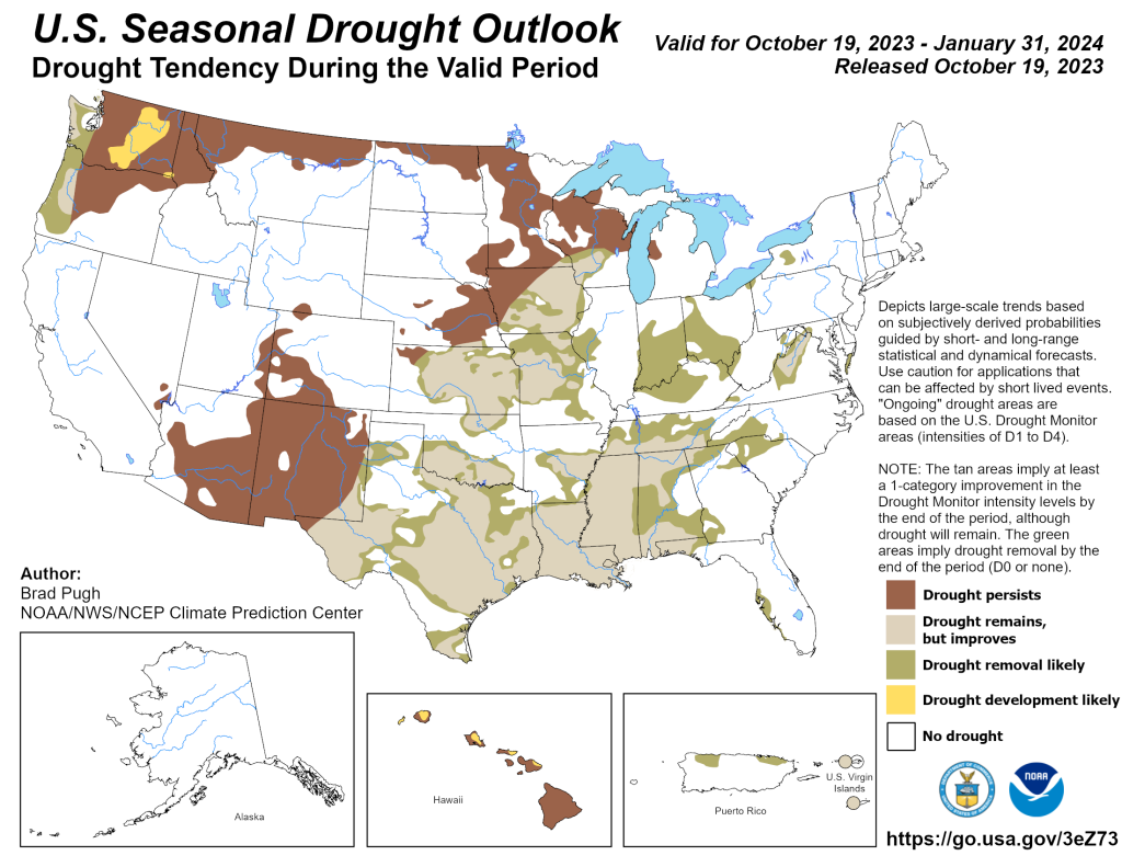
Extreme drought continued in late October from Columbus, Neb., south into Grand Island and Hastings southward into north central Kansas and a large chunk of Kansas (except extreme southwest Kansas).
Regarding winter temperatures, parts of north central and northeast Nebraska are expected to be warmer than normal (~40%).
“Even with the strong El Nino event, outlooks of expected weather conditions are not guarantees,” Moritz noted.
KANSAS
For Kansas, forecasting El Nino’s impact this winter is somewhat challenging, because Kansas isn’t far enough north to really get in on the above normal temperatures and not far enough south to be ‘thrown into’ the cool or even normal temps. The CPC split Kansas’ precipitation forecast in half, with increased precipitation chances starting from extreme southwest Kansas in a line up to extreme northeast Kansas including locations south of that line, which is much of southern/central/east and northeast Kansas. For the rest of Kansas near-normal winter precipitation. Temperatures are forecast to be above normal for north central, east and southeast Kansas. The rest of Kansas has equal chances of either normal, above or below normal temps.
“For precipitation in Kansas, the slight tendency is for wetter conditions especially in late winter to spring. So possibly nothing special about November, December and January but February into spring could see an uptick, but the probabilities are not strong,” said Doug Kluck, Central Region Climate Services director-NOAA’s National Center for Environmental Information based in Kansas City, Mo.
Although in a flip flop of the state’s typical moisture pattern this past year, western Kansas has received timely moisture and is drought free, however much of central and eastern Kansas still has persistent and worsening drought, resulting in substantial crop, cattle and public water supply impacts.
El Nino remains a headline, however drought is expected to persist in November.
But, as winter sets in, CPC forecasts suggest El Nino’s influences result in above normal moisture from one or more large synoptic systems.
“With the PDO (Pacific Decadal Oscillation) and potential for an active Arctic Oscillation (AO/Polar Vortex) this winter, periods of cold are likely. When combined with these systems, it could potentially increase the probability of wintry precipitation compared to previous years, although temporally limited with overall dryness residing between them and across the region,” said Christopher “Chip” Redmond, Kansas State University meteorologist and Kansas Mesonet manager.
Also with higher than normal grass growth in west and southern Kansas, any prolonged period of warm/dry conditions could yield above normal wildfire concerns. The hope is that an early snow/ice event would lessen overall concern by peak fire season in the spring, Redmond said.
Lastly, with recent moisture this fall, winter wheat has emerged and seems to be relatively healthy. With the outlook for above normal moisture this winter, wheat would result better than last winter and have adequate soil moisture for spring growth.
COLORADO
El Nino’s typical winter pattern is shaping up for Colorado, which means temperatures are forecast to be near normal across Colorado into western Kansas, then increasing to above normal the further north you go.
“This looks very similar to the “normal” El Nino pattern, where the northern half of the U.S. is warmer, and cooler further south. The CPC precipitation forecast for Colorado also follows along with the typical El Nino pattern, with wetter than normal conditions south, drier north,” said Kyle Mozley, meteorologist; NWS-Pueblo, Colo. Wetter; especially starting in late October into November.
CPC forecasts better chances for precipitation for eastern Colorado, eastern Wyoming, western Kansas and western Nebraska.
“Of course, every El Nino is different, but given the strong event (the associated equation currently around +2C in Nino3.4), the impacts will likely be similar to other stronger events (2015-16, 1997-98, 1982-83). In those cases, (October-March), eastern Colorado east into the Missouri Valley had above normal precipitation. This jives well with the CPC outlook too,” Mozley said.
The spring months will likely be where most of the seasonal precipitation falls.
Looking at drought, western Colorado is in D0-D2. The rest of the area is drought free.
WYOMING
This current El Nino is strengthening and will likely be moderate to strong at its peak late this year/early next year, said a Wyoming climate specialist, who just did a deep dive into Wyoming climatology over the last 25 El Nino events. With the exception of the eastern Plains, two-thirds of the last 25 El Ninos produced above-average winter temperatures. Precipitation in the west and northwest, and a few other higher elevation areas were associated with below average precipitation, like 75% of the last 25 El Nino occurrences. Regions on both maps in the 40% to 60% range have: average temperatures or precipitation.
“The Climate Prediction Center’s outlook for December thru February shows the southern half of Wyoming having equal chances for experiencing either: above/normal/or below-normal temperatures. For precipitation, there’s a sliver in southern Wyoming where the odds favor above normal precipitation with a large swath in between having the potential to go either way,” said Tony Bergantino, director, Wyoming State Climate Office, Water Resources Data System-University of Wyoming, Department of Atmospheric Science and Wyoming CoCoRaHS State Coordinator, Wyoming Mesonet director. Wyoming is situated in the boundary area (which can be fairly wide) between the various influences of El Nino (and La Nina for that matter).
“It couldn’t get much wetter than it has been in Wyoming this past year, meanwhile with El Nino the tendency is drier and warmer than normal overall temperatures,” Kluck said. “That doesn’t mean an Arctic outbreak and -30F temperatures won’t happen, but it leans towards fewer of those than normal, and relatively mild conditions.”
With hope on the horizon for increased wetness, El Niño will be closely watched by farmers and ranchers.